2024/10/21

Java Json library: Jackson, Gson Tree Model

因為 Json 文件本身就是一個樹狀結構,處理 JSON 的 libary 都有對應可處理每一個 json property node 的工具,以下記錄如何使用 Jackson 與 Gson,對 json 做 pretty print,parsing 每個節點,新增/移除節點的方法。

pom

在 pom.xml 加上兩個 libary 的來源

        <!-- https://mvnrepository.com/artifact/com.fasterxml.jackson.core/jackson-databind -->
        <dependency>
            <groupId>com.fasterxml.jackson.core</groupId>
            <artifactId>jackson-databind</artifactId>
            <version>2.17.0</version>
        </dependency>

        <!-- https://mvnrepository.com/artifact/com.google.code.gson/gson -->
        <dependency>
            <groupId>com.google.code.gson</groupId>
            <artifactId>gson</artifactId>
            <version>2.10.1</version>
        </dependency>

Gson

package json;
import com.google.gson.*;

public class GsonTester {
    public static void main(String args[]) {

        String jsonString =
                "{\"name\":\"John Lin\", \"age\":21,\"verified\":false,\"geo\": [100.11,90.85]}";
//        System.out.println("jsonString="+jsonString);

        // 以 JsonParser parsing 後,取得 JsonObject
        JsonObject details = JsonParser.parseString(jsonString).getAsJsonObject();

        //************/
        // pretty print json string
//            {
//                "name" : "John Lin",
//                "age" : 21,
//                "verified" : false,
//                "geo" : [
//                    100.11,
//                    90.85
//                ]
//            }
//        System.out.println(details.toString());

        System.out.println();
        System.out.println("*** original Json");
        Gson gson = new GsonBuilder().setPrettyPrinting().create();
        String jsonOutput = gson.toJson(details);
        System.out.println(jsonOutput);

        //************/
        // parsing json
        System.out.println();
        System.out.println("*** parsing Json");
        if (details.isJsonObject()) {
            // JsonElement 對應 "name":"John Lin"
            JsonElement nameNode = details.get("name");
            System.out.println("Name: " +nameNode.getAsString());

            JsonElement ageNode = details.get("age");
            System.out.println("Age: " + ageNode.getAsInt());

            JsonElement verifiedNode = details.get("verified");
            System.out.println("Verified: " + (verifiedNode.getAsBoolean() ? "Yes":"No"));

            // JsonArray 對應 [100.11,90.85]
            JsonArray geoNode = details.getAsJsonArray("geo");
            System.out.print("geo: ");
            for (int i = 0; i < geoNode.size(); i++) {
                JsonPrimitive value = geoNode.get(i).getAsJsonPrimitive();
                System.out.print(value.getAsFloat() + " ");
            }
            System.out.println();
        }

        //************/
        // add/remove property
        System.out.println();
        System.out.println("*** new Json After add/remove property");
        details.addProperty("school", "Tsing-Hua");
        details.remove("verified");
        String jsonOutput2 = gson.toJson(details);
        System.out.println(jsonOutput2);
    }
}

Jackson

package json;

import com.fasterxml.jackson.core.JsonProcessingException;
import com.fasterxml.jackson.databind.JsonMappingException;
import com.fasterxml.jackson.databind.JsonNode;
import com.fasterxml.jackson.databind.ObjectMapper;
import com.fasterxml.jackson.databind.node.ObjectNode;
import com.google.gson.Gson;
import com.google.gson.GsonBuilder;
import com.google.gson.JsonPrimitive;

public class JacksonTest {
    public static void main(String args[]) {
        try {
            String jsonString =
                    "{\"name\":\"John Lin\", \"age\":21,\"verified\":false,\"geo\": [100.11,90.85]}";
            ObjectMapper mapper = new ObjectMapper();
            JsonNode jsonObject = mapper.readTree(jsonString);

            //************/
            // pretty print json string
//            {
//                "name" : "John Lin",
//                    "age" : 21,
//                    "verified" : false,
//                    "geo" : [ 100.11, 90.85 ]
//            }
            System.out.println();
            System.out.println("*** original Json");
            String prettyJson = mapper.writerWithDefaultPrettyPrinter().writeValueAsString(jsonObject);
            System.out.println(prettyJson);

            //************/
            // parsing json
            System.out.println();
            System.out.println("*** parsing Json");
            JsonNode jsonNodeName = jsonObject.get("name");
            System.out.println("Name: " +jsonNodeName.asText() );

            JsonNode jsonNodeAge = jsonObject.get("age");
            System.out.println("Age: " + jsonNodeAge.asInt());

            JsonNode jsonNodeVerified = jsonObject.get("verified");
            System.out.println("Verified: " + (jsonNodeVerified.asBoolean() ? "Yes":"No"));

            JsonNode jsonNodeGeo = jsonObject.get("geo");
            System.out.print("geo: ");
            for (int i = 0; i < jsonNodeGeo.size(); i++) {
                double value = jsonNodeGeo.get(i).asDouble();
                System.out.print(value + " ");
            }
            System.out.println();

            //************/
            // add/remove property
            System.out.println();
            System.out.println("*** new Json After add/remove property");
            ObjectNode jsonObject2 = ((ObjectNode) jsonObject).put("school", "Tsing-Hua");
            JsonNode removedNode = jsonObject2.remove("verified" );
            String prettyJson2 = mapper.writerWithDefaultPrettyPrinter().writeValueAsString(jsonObject2);
            System.out.println(prettyJson2);

        } catch (JsonProcessingException e1) {

        }
    }
}

結果

*** original Json
{
  "name" : "John Lin",
  "age" : 21,
  "verified" : false,
  "geo" : [ 100.11, 90.85 ]
}

*** parsing Json
Name: John Lin
Age: 21
Verified: No
geo: 100.11 90.85 

*** new Json After add/remove property
{
  "name" : "John Lin",
  "age" : 21,
  "geo" : [ 100.11, 90.85 ],
  "school" : "Tsing-Hua"
}

References

Gson - Tree Model

Working with Tree Model Nodes in Jackson | Baeldung

Jackson - Marshall String to JsonNode | Baeldung

Pretty-Print a JSON in Java | Baeldung

2024/10/14

TopoJSON, GeoJSON

GeoJSON 是一種用 JSON 文件格式描述地圖的格式,2016 年 IETF 於 RFC 7946 規範了 GeoJSON 的規格。GeoJSON 的幾何物件有點:表示地理位置、線:表示街道公路邊界、多邊形:表示國家鄉鎮市界。

TopoJSON 是 GeoJSON 的擴充,TopoJSON 以一連串的點組合成的 Arcs 描述,line 與 polygon 都改用 arcs 描述,如果是邊界,在 TopoJSON 裡面的 arc 只會定義一次,這樣可有效減少文件的大小。

要將 TopoJSON 與 GeoJSON 文件互相轉換,可使用 node module

npm install topojson
npm install geojson

安裝後切換到 node_modules/topojson/node_modules/topojson-server/bin 這個目錄,可看到 geo2topo 指令

以下指令可將 GeoJSON 檔案轉換為 TopoJSON

./geo2topo towns-09007.geo.json > towns-09007.topo.json

切換到 node_modules/topojson/node_modules/topojson-client/bin 這個目錄,可看到 topo2geo 指令

這個指令可查詢 TopoJSON 裡面的地圖名稱

./topo2geo -l < towns-090007.topo.json
# towns-09007.geo

這邊會查詢到名稱為 towns-09007.geo

用以下指令將 TopoJSON 轉為 GeoJSON

./topo2geo towns-09007.geo=towns-090007-2.geo.json < towns-090007.topo.json

java jts library

以下節錄 GeoJSON 文件結構

{
    "type": "FeatureCollection",
    "features": [
        {
            "type": "Feature",
            "properties": {
                "id": "10005160",
                "name": "三灣鄉"
            },
            "geometry": {
                "type": "Polygon",
                "coordinates": [
                    [
                        [
                            120.97453105516638,
                            24.583295428280817
                        ],
                        [
                            120.96669830509721,
                            24.586708627549427
                        ],
                        ......
                    ]
                ]
            },
            ......
        }
    ]
}

這邊使用了兩個 library: jts, jackson,jackson 是處理 JSON 文件,jts 是處理向量圖形的 library

        <!-- https://github.com/locationtech/jts -->
        <!-- https://mvnrepository.com/artifact/org.locationtech.jts/jts-core -->
        <dependency>
            <groupId>org.locationtech.jts</groupId>
            <artifactId>jts-core</artifactId>
            <version>1.19.0</version>
        </dependency>
        <dependency>
            <groupId>org.locationtech.jts.io</groupId>
            <artifactId>jts-io-common</artifactId>
            <version>1.19.0</version>
        </dependency>

        <!-- https://mvnrepository.com/artifact/com.fasterxml.jackson.core/jackson-databind -->
        <dependency>
            <groupId>com.fasterxml.jackson.core</groupId>
            <artifactId>jackson-databind</artifactId>
            <version>2.17.0</version>
        </dependency>

透過 Jackson,將 FeatureCollection 裡面的 features array 分開,每一個獨立去查詢,GPS 點跟 每一個 feature 的 Polygon// 測試每一個 point 跟 polygon 的關係。

相關的 methods 有這些:

  • 相等(Equals):幾何形狀拓撲上相等。

  • 脫節(Disjoint):幾何形狀沒有共有的點。

  • 相交(Intersects):幾何形狀至少有一個共有點(區別於脫節)

  • 接觸(Touches):幾何形狀有至少一個公共的邊界點,但是沒有內部點。

  • 交叉(Crosses):幾何形狀共享一些但不是所有的內部點。

  • 內含(Within):幾何形狀A的線都在幾何形狀B內部。

  • 包含(Contains):幾何形狀B的線都在幾何形狀A內部(區別於內含)

  • 重疊(Overlaps):幾何形狀共享一部分但不是所有的公共點,而且相交處有他們自己相同的區域。

import com.fasterxml.jackson.databind.JsonNode;
import com.fasterxml.jackson.databind.ObjectMapper;
import com.fasterxml.jackson.databind.node.JsonNodeType;
import com.fasterxml.jackson.databind.node.ObjectNode;
import org.locationtech.jts.geom.*;
import org.locationtech.jts.io.ParseException;
import org.locationtech.jts.io.geojson.GeoJsonReader;

import java.io.File;
import java.io.IOException;

public class PointInsidePolygon {

    public static void main(String[] args) throws IOException {
        // https://blog.csdn.net/qq_36427942/article/details/129123733
        // jackson lib to read json document
        ObjectMapper mapper = new ObjectMapper();
        ObjectNode geoJsonObject = (ObjectNode) mapper.readTree(new File("towns-10005.geo.json"));

//        System.out.println("geoJsonObject.toString()="+geoJsonObject.toString());

        // 透過 Jackson,將 FeatureCollection 裡面的 features array 分開
        // 每一個獨立去查詢,GPS 點跟 每一個 feature 的 Polygon
        // 測試每一個 point 跟 polygon 的關係
        Coordinate GPSPint = new Coordinate(120.97453105516638,24.583295428280817);
        JsonNode node2 = geoJsonObject.get("features");
//        System.out.println("node2="+node2);
        for(JsonNode node3: node2) {
//            System.out.println("node3="+node3);
            JsonNodeType node3Type = node3.getNodeType();
            JsonNode node3PropertiesNode = node3.get("properties");
            JsonNode node3PropertiesId = node3PropertiesNode.get("id");
            JsonNode node3PropertiesName = node3PropertiesNode.get("name");

            System.out.println("");
            System.out.println("node3PropertiesId="+node3PropertiesId+", node3PropertiesName="+node3PropertiesName);

            GeoJsonReader reader = new GeoJsonReader();
            Geometry geometry = null;
            try {
                geometry = reader.read(node3.toString());
            } catch (ParseException e) {
                throw new RuntimeException(e);
            }

            String geometryType = geometry.getGeometryType();
            // geometryType=GeometryCollection
            System.out.println("geometryType="+geometryType+", length="+ geometry.getLength());

//        Coordinate[] cors = geometry.getCoordinates();
//        System.out.println("cors length="+cors.length);
//        for(Coordinate c: cors) {
//            System.out.println("c ="+c.toString() );
//        }
            // get ExteriorRing
            if (geometry instanceof Polygon) {
                geometry = ((Polygon) geometry).getExteriorRing();
            } else {
                System.err.println("Invalid Polygon");
                return;
            }

            // JTS Geometry
            GeometryFactory geometryFactory = new GeometryFactory();
            Coordinate[] coordinates = geometry.getCoordinates();
            Coordinate[] jtsCoordinates = new Coordinate[coordinates.length];
            for (int i = 0; i < coordinates.length; i++) {
                jtsCoordinates[i] = new Coordinate(coordinates[i].x, coordinates[i].y);
            }
            Polygon polygon = geometryFactory.createPolygon(jtsCoordinates);

            // GPS Point
            Point gpsPoint = geometryFactory.createPoint(GPSPint);

//            相等(Equals):幾何形狀拓撲上相等。
//            脫節(Disjoint):幾何形狀沒有共有的點。
//            相交(Intersects):幾何形狀至少有一個共有點(區別於脫節)
//            接觸(Touches):幾何形狀有至少一個公共的邊界點,但是沒有內部點。
//            交叉(Crosses):幾何形狀共享一些但不是所有的內部點。
//            內含(Within):幾何形狀A的線都在幾何形狀B內部。
//            包含(Contains):幾何形狀B的線都在幾何形狀A內部(區別於內含)
//            重疊(Overlaps):幾何形狀共享一部分但不是所有的公共點,而且相交處有他們自己相同的區域。
            boolean isInside = polygon.contains(gpsPoint);
            boolean isWithin = polygon.within(gpsPoint);
            boolean intersects = polygon.intersects(gpsPoint);
            boolean overlaps = polygon.overlaps(gpsPoint);
            boolean crosses = polygon.crosses(gpsPoint);
            boolean touches = polygon.touches(gpsPoint);
            boolean disjoint = polygon.disjoint(gpsPoint);

            System.out.println("gps "+gpsPoint);
            System.out.println(" contains=" + isInside+", within=" + isWithin+", intersects="+intersects+". overlaps="+overlaps+", crosses="+crosses+", touches="+ touches+", disjoint="+disjoint);
        }
    }
}

執行結果如下:

node3PropertiesId="10005160", node3PropertiesName="三灣鄉"
geometryType=Polygon, length=0.4571892567423512
gps POINT (120.97453105516638 24.583295428280817)
 contains=false, within=false, intersects=true. overlaps=false, crosses=false, touches=true, disjoint=false

node3PropertiesId="10005110", node3PropertiesName="南庄鄉"
geometryType=Polygon, length=0.6073270143853203
gps POINT (120.97453105516638 24.583295428280817)
 contains=false, within=false, intersects=true. overlaps=false, crosses=false, touches=true, disjoint=false

node3PropertiesId="10005010", node3PropertiesName="苗栗市"
geometryType=Polygon, length=0.26286982385854196
gps POINT (120.97453105516638 24.583295428280817)
 contains=false, within=false, intersects=false. overlaps=false, crosses=false, touches=false, disjoint=true

References

D3.js應用

「GIS教程」将GeoJSON转换成TopoJSON的方法 | 麻辣GIS

GeoJSON - Wikipedia

2024/9/30

RTSP

RTSP是1996年由 RealNetworks, Netscape, 哥倫比亞大學開發,提交草案給 IETF,1998年發布為 RFC2326,2016年RTSP 2.0 發布於 RFC 7826。RTSP 是串流媒體伺服器的控制協定,可建立與控制終端設備跟伺服器之間的多媒體 session。

RTSP 協定本身看起來跟 HTTP 類似,但 HTTP 本身是 stateless,而RTSP 是 stateful,故需要追蹤 session。RTSP 是用 TCP 連線,而多媒體本身,是用 RTP 傳輸,可以用 TCP 或 UDP,常見狀況是為求傳輸速度快,使用 UDP。

節錄一個 RTSP client 取得 RTSP 的封包過程

  1. Options

    查詢 RTSP server 支援的 command

    Client -> Server

    Request: OPTIONS rtsp://192.168.1.11:8554/mystream RTSP/1.0\r\n
    CSeq: 2\r\n
    User-Agent: LibVLC/3.0.20 (LIVE555 Streaming Media v2016.11.28)\r\n
    \r\n

    Server -> Client

    Response: RTSP/1.0 200 OK\r\n
    CSeq: 2\r\n
    Public: DESCRIBE, ANNOUNCE, SETUP, PLAY, RECORD, PAUSE, GET_PARAMETER, TEARDOWN\r\n
    Server: gortsplib\r\n
    \r\n
  2. Describe

    查詢可處理的多媒體資料格式,server 以 SDP 方式回覆

    Client -> Server

    Request: DESCRIBE rtsp://192.168.1.11:8554/mystream RTSP/1.0\r\n
    CSeq: 3\r\n
    User-Agent: LibVLC/3.0.20 (LIVE555 Streaming Media v2016.11.28)\r\n
    Accept: application/sdp\r\n
    \r\n

    Server -> Client

    Response: RTSP/1.0 200 OK\r\n
    CSeq: 3\r\n
    Content-Base: rtsp://192.168.1.11:8554/mystream/\r\n
    Content-length: 560
    Content-type: application/sdp
    Server: gortsplib\r\n
    \r\n
    Session Description Protocol Version (v): 0
    Owner/Creator, Session Id (o): - 0 0 IN IP4 127.0.0.1
    Session Name (s): test
    Connection Information (c): IN IP4 0.0.0.0
    Time Description, active time (t): 0 0
    Media Description, name and address (m): video 0 RTP/AVP 96
    Media Attribute (a): control:rtsp://192.168.1.11:8554/mystream/trackID=0
    Media Attribute (a): rtpmap:96 H264/90000
    Media Attribute (a): fmtp:96 packetization-mode=1; profile-level-id=640032; sprop-parameter-sets=Z2QAMqzIUB4AiflwEQAAAwPpAAC7gA8YMZY=,aOk4XLIs
    Media Description, name and address (m): audio 0 RTP/AVP 97
    Media Attribute (a): control:rtsp://192.168.1.11:8554/mystream/trackID=1
    Media Attribute (a): rtpmap:97 mpeg4-generic/48000/2
    Media Attribute (a): fmtp:97 config=1190; indexdeltalength=3; indexlength=3; mode=AAC-hbr; profile-level-id=1; sizelength=13; streamtype=5
  3. Setup

    要求 server 設定傳送某一個 media stream,setup 要在 play 之前完成

    Client -> Server

    Request: SETUP rtsp://192.168.1.11:8554/mystream/trackID=0 RTSP/1.0\r\n
    CSeq: 4\r\n
    User-Agent: LibVLC/3.0.20 (LIVE555 Streaming Media v2016.11.28)\r\n
    Transport: RTP/AVP/TCP;unicast;interleaved=0-1
    \r\n

    Server -> Client

    Response: RTSP/1.0 200 OK\r\n
    CSeq: 4\r\n
    Server: gortsplib\r\n
    Session: 262553a7d5084e8fb57f9d8f485c89f4
    Transport: RTP/AVP/TCP;unicast;interleaved=0-1;ssrc=03DAD41B
    \r\n
  4. Setup

    client 透過 setup 跟 server 確認 stream session

    Client -> Server

    Request: SETUP rtsp://192.168.1.11:8554/mystream/trackID=1 RTSP/1.0\r\n
    CSeq: 5\r\n
    User-Agent: LibVLC/3.0.20 (LIVE555 Streaming Media v2016.11.28)\r\n
    Transport: RTP/AVP/TCP;unicast;interleaved=2-3
    Session: 262553a7d5084e8fb57f9d8f485c89f4
    \r\n

    Server -> Client

    Response: RTSP/1.0 200 OK\r\n
    CSeq: 5\r\n
    Server: gortsplib\r\n
    Session: 262553a7d5084e8fb57f9d8f485c89f4
    Transport: RTP/AVP/TCP;unicast;interleaved=2-3;ssrc=294122AE
    \r\n
  5. Play

    在 setup 設定的 session 裡面,開始播放 media

    Client -> Server

    Request: PLAY rtsp://192.168.1.11:8554/mystream/ RTSP/1.0\r\n
    CSeq: 6\r\n
    User-Agent: LibVLC/3.0.20 (LIVE555 Streaming Media v2016.11.28)\r\n
    Session: 262553a7d5084e8fb57f9d8f485c89f4
    Range: npt=0.000-\r\n
    \r\n

    Server -> Client

    Response: RTSP/1.0 200 OK\r\n
    CSeq: 6\r\n
    RTP-Info: url=rtsp://192.168.1.11:8554/mystream/trackID=0;seq=10453;rtptime=1024864644,url=rtsp://192.168.1.11:8554/mystream/trackID=1;seq=4824;rtptime=3779844790\r\n
    Server: gortsplib\r\n
    Session: 262553a7d5084e8fb57f9d8f485c89f4
    \r\n
  6. RTP

    用 RTP 的格式,傳送 media 內容

    Server -> Client

    10.. .... = Version: RFC 1889 Version (2)
    ..0. .... = Padding: False
    ...0 .... = Extension: False
    .... 0000 = Contributing source identifiers count: 0
    0... .... = Marker: False
    Payload type: DynamicRTP-Type-96 (96)
    Sequence number: 10453
    Timestamp: 1024871144
    Synchronization Source identifier: 0x03dad41b (64672795)
    Payload: 09f0
  7. Teardown

    client 通知 server 停止播放 media

    Client -> Server

    Request: TEARDOWN rtsp://192.168.1.11:8554/mystream/ RTSP/1.0\r\n
    CSeq: 7\r\n
    User-Agent: LibVLC/3.0.20 (LIVE555 Streaming Media v2016.11.28)\r\n
    Session: 262553a7d5084e8fb57f9d8f485c89f4
    \r\n

References

即時串流協定 - 維基百科,自由的百科全書

2024/9/23

Secure Reliable Transport (SRT)

Secure Reliable Transport (SRT) 是開放的 video transport protocol,由 Halvision 提出,目的是要提供一個加密、低延遲的視訊串流傳輸協定,過去比較常見的協定是 RTMP, RTSP, HLS, WebRTC。SRT 是在 2013 年由 Haivision 發表,後來 Haivision 在 2017 年將 protocol 開放,交給 SRT Alliance,然後慢慢有更多廠商支援這個協定。

在這麼長久的網路視訊串流發展歷史中,RTMP 常見於網路影片直播,尤其是行動網路的直播,RTSP 常見於網路攝影機。RTMP 是以 TCP 為基礎,因為發展當時的網路頻寬不大,必須要用 TCP 本身的連線穩定度,封包傳送機制,來確保網路直播的可用性。

SRT 則是完全使用 UDP,在 Haivision 的文件中,提出 SRT 的延遲比 RTMP 少 2.5~3.2 倍。SRT 跟 RTP 的差異是,SRT 借鑒了 RTMP 控制機制,傳輸中除了 video 資料封包,還有控制封包,控制封包可根據網路延遲及品質,動態調整發送端的 video 發送速度,也能有限制地決定要不要重傳遺失的封包。

SRT 可套用加密機制,使用最常見的 AES-128/256 加密方法。

SRT 只是一種影片切割與包裝的方法,因此能適用於任何一種影片 codec。

Server

GitHub - Edward-Wu/srt-live-server: srt live server for low latency 這是一個 SRT streaming server。

安裝前,必須要先安裝 GitHub - Haivision/srt: Secure, Reliable, Transport SRT library,我們在 CentOS 測試,根據這個文件說明,依照以下步驟安裝

sudo yum install tcl pkgconfig openssl-devel cmake gcc gcc-c++ make automake
./configure
make
make install

安裝 SRT library 後,可安裝 server,下載 srt-live-server-master.zip,解壓縮後,直接 make 即可

sudo make

執行

cd bin
./sls -c ../sls.conf

Client

測試 SRT 可使用 OBS Studio

發布的網址為

srt://192.168.1.11:8080?streamid=uplive.sls.com/live/test

接收部分,可用 VLC video player 測試,網址為

srt://192.168.1.11:8080?streamid=live.sls.com/live/test

實際上實測,OBS 發佈到 VLC 接收,大約有 4~5 秒的延遲

iOS app

可安裝 Haivision Play Pro - Haivision iOS APP,這個 app 也可以接收 SRT streaming

設定方式如下

References

什麼是SRT 安全可靠傳輸協議

Secure Reliable Transport - Wikipedia

【ProAV Lab】SRT,互聯網上的最佳視訊串流協定 | Lumens

RTMP vs. SRT: Comparing Latency and Maximum Bandwidth - Haivision

2024/9/9

InfiniBand IB

作為網路互連的技術方案,Ethernet 跟 InfiniBand (IB) 兩者的發展目標不同,導致現在應用的領域跟範圍都不同。

  • 使用場景

一般人比較常聽到 Ethernet,Ethernet 用在區域網路中,可將多個網路設備連接起來,以光纖連接 Internet,以無線網路連接手持設備。InfiniteBand 主要用在HPC 與 data center,這類對高頻寬低延遲的網路連接需求較高的應用場景

  • 頻寬

Ethernet 的應用發展,並不是以高速頻寬為主要發展的重點,他的重點在讓多種異質網路終端能夠互相連接起來,所以頻寬並不是發展的重點。通常 Ethernet 是在 1Gbps 到 100 Gbps,而InfiniBand 可到 100 Gbps 或 200 Gbps,像這份報導的說明,InfiniBand進入400Gb/s世代,Nvidia新款網路交換器揭開序幕 | iThome 已經到了 400Gbps 的時代。

  • 應用範圍

Ethneret 面向一般終端的消費者,用來做個人使用的資料傳輸並連接 Internet。InfiniBand 是用在大量的資料運算,在現在最熱門的 AI 時代,要建構一個 AI cluster,會使用 InfiniBand 作為 cluster 節點的連接技術。

InfiniBand 另一個應用是在超級電腦裡面,因為超級電腦叢集也需要這種高速低延遲的資料傳輸。

  • 成本

InfiniBnad 的效能高,相對成本就很高,沒有特殊的需求,一般是不會使用 InfiniBand

  • 網路模式

InfiniBand 比 Ethernet 容易管理,每一個 end node 會透過一個 layer 2 switch 配置網路節點 ID,再往上以 Router 統計計算網路資料轉發路徑。

Ethernet 是用硬體的 MAC 網路模式,往上使用 IP 搭配 ARP 建構網路,且網路本身沒有學習機制,容易產生環狀網路,這又要透過 STP 協定解決,增加了網路的複雜度

Socket Direct Protocol (SDP)

Trail: Sockets Direct Protocol (The Java™ Tutorials)

Java 7 Sockets Direct Protocol – Write Once, Run Everywhere …. and Run (Some Places) Blazingly - InfoQ

SDP

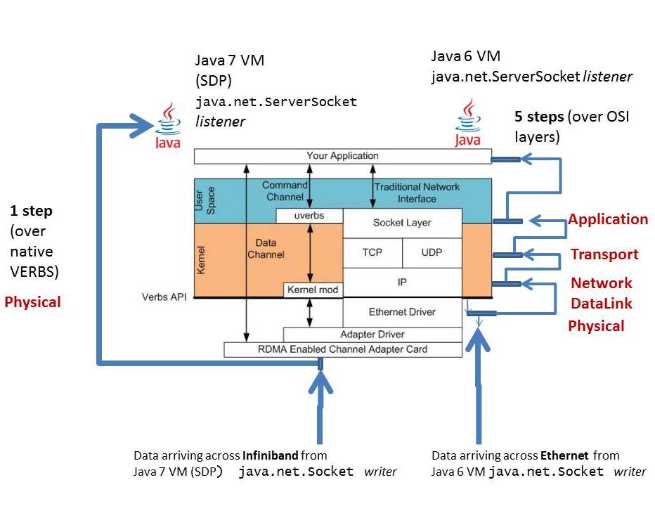
在 JDK 7 裡面,就提供了一種不同於 TCP/IP 傳統的 Socket 網路的 Socket Direct Protocol,SDP 能夠透過 InifiBand 的 Remote Direct Memory Access (RDMA) ,以低延遲的方法,不透過 OS,遠端存取其他電腦的記憶體。

透過這張圖的說明,可以了解為什麼 SDP 能夠提供高速的通訊,傳統的 TCP/IP 需要一層一層接過 Application Layer -> Transport Layer -> Network Layer -> Physical Layer,SDP 則是從 Application 一步直接穿到 RDMA enabled channel adapter card

參考這個連結的圖片: SDP

References

InfiniBand - 維基百科,自由的百科全書

InfiniBand與以太網:它們是什麼? | 飛速(FS)社區

InfiniBand之技術架構介紹